- 17th century
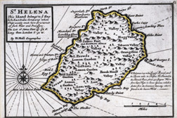
Used as a watering stop for East India Company ships and as a location from which the Royal Navy could dominate the South Atlantic, St. Helena was a mountainous tropical island a mere 28 miles in circumference. The nearest land, the west coast of Africa, was 1,140 miles away. A “buoy lost in the South Atlantic,” it was hell on earth for a man of Napoléon’s active temperament.
Historical Provenance - Ink on paper

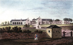
“View of Buonaparte’s New Mansion”
From "A Traveller’s Notebook, or From Buonaparte to Longwood" - 1819
After a few months in Jamestown, the port of St. Helena, Napoléon was moved five miles away to Longwood, a converted farmhouse at 1,700 feet elevation. Here he would spend the last five and a half years of his life in a suite of rooms comprising a study, drawing room, antechamber, bathroom and bedroom. Napoléon received this book about himself while in exile in 1820.
Historical Provenance - Napoléon’s library, Bertrand family collection
Colored engraving on paper
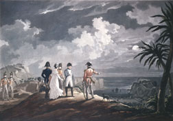
“Bonaparte

on St. Helena Island”
Jean-Pierre Marie Jazet - c. 1825
Napoléon and his small entourage, presumably here being shown their barren new home by the red-coated British captors, did their best to pass the time and relieve the boredom by taking walks, playing cards and dining at the Emperor’s table.
Engraving on paper

No comments:
Post a Comment